Solar Energy in China
Background
Hand in hand with the rapid economic development of China during the last decades, the energy consumption has increased enormously. In this process, solar power has become an increasingly important part of China’s energy mix as the country seeks to reduce its reliance on fossil fuels and tackle air pollution. The country has set ambitious targets to increase the use of renewable energy, including a target to have 20% of its total energy consumption come from renewable sources by 2025.
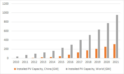 Diagram: Development of installed photovoltaic capacity, China and World.
One of the most impressive examples of China’s progress in this field is the Tengger Desert Solar Park. Its construction began in 2015 and was completed in 2020. This solar park is located in the Tengger Desert in the northwest Ningxia Hui Autonomous Region, only a few kilometers north of the Huang He (Yellow River), one of China’s biggest rivers. Covering an area of 43 km², the power plant has a total peak capacity of more than 1500 megawatts (MW). This made it the sixth-largest solar facility in the world by the end of 2021.
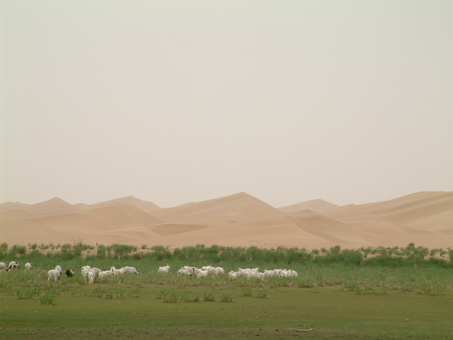 In addition to producing renewable energy, the Tengger Desert Solar Park helps to combat desertification in the area. The park’s solar panels provide shade to the desert floor, which helps to reduce evaporation and keep the soil moist. This can help to prevent the expansion of the desert and protect the local ecosystem.
Exercises
- Satellite Map:
- Look at the satellite map.
- What can you see? Describe the surface structures.
- Describe the different landcover and landuse zones visible in the satellite image. Identify natural and man-made structures.
- In which landcover zone is the solar power plant located? Try to find reasons for this selection of the location.
- Can you identify disadvantages of the location of the solar power plant in the desert?
- EO Browser:
- Open the EO Browser.
- Find the most recent Sentinel-2 dataset covering the area displayed in the satellite map.
- Select a true colour visualisation.
- Can you identify additional, recent changes in the area (check e.g. desert, solar power installations, and agricultural land)?
- Compare with the Satellite Map. Can you identify additional substantial changes?
- Select the false colour infrared representation. Can you identify the land-use of the most intensely vegetated areas (represented by bright red colours)?
Links and Sources
| Links: |